Document

North East Corner of Kent
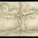
This is a map of the north east corner of Kent. It forms part of an atlas that belonged to William Cecil Lord Burghley, Elizabeth I’s Secretary of State. Burghley used this atlas to illustrate domestic matters. It is though to be by William Lambard. Lambard is known to have been working in Kent during the 1580s and 1590s, producing a map of the beacon network of Kent in 1585. Here the waterways are the dominant feature. These were the most effective mode of transport and knowledge of them was vital in order to protect the country as they made it possible to manoeuvre troops and weaponry in large quantities relatively fast. Given the fact that Lambard was engaged in producing a map of the beacon network of the area, it is likely that this map was also produced with the idea of defence in mind. The threat from Spain reached it climax in the 1580s with the events of the Sapnish Armada in 1588. The earlier years of the decade saw defensive preparations take place and the proximity of this area to London would have made a detailed understanding of its communication routes vital. Lord Burghley has written on the reverse of the map: "River of Stowre betwixt Sandwych and Fordwych" highlighting that the important feature of the map is indeed the waterways.
The British Library[Lambard, William]
1585

